
April 2006
This was a wonderful walk over the famous white cliffs of the Kent coast, passing the major port of Dover and ending at the absolutely beautiful village of St Margaret’s at Cliffe.
I started from home and drove down to Capel-le-Ferne where I had ended my last walk. I drove down via the M25, M26 and M20 and parked on the road just near the bus stop where I had ended my last walk.
It took me only a few minutes to walk down to the coast and enjoy the views back over Folkestone and The Warren below me.

This is in fact an ancient landslip and it reminded me a little of the south coast of the Isle of Wight which also has an “Undercliff” area, though the geology there is different. Looking down below I had been surprised on my first visit to find a railway line running right along the coast here. Having lived previously in Devon I thought that county had a monopoly on coastal railway lines!

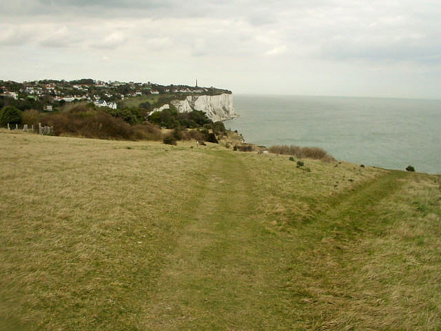
Immediately there was an excellent coast path running right along the top of the cliffs, above the Warren. This is part of the North Downs Way, a long distance National Trail that follows the chalk ridge of the North Downs from Farnham in Surrey to Dover. The white cliffs are of course the most visible and perhaps most famous part of the North Downs. Though here there was not much chalk to be seen because the main cliff face is protected from the erosion of the sea by the Warren and the railway line which runs below the base of the cliffs.
The area below, The Warren, is actually open the public and I could see a caravan site down there, but I was not sure of access out of the area, so stuck to the cliff top.

This is the route of the new England Coast Path which is now marked on maps of the area, too. Down below I could see trains running along the tracks on their way to and from Dover.


It looked a spectacular ride and I was a little disappointed that my route back would be by bus, since neither my start or end point had railway stations, so I’d not be travelling the line today.
Looking back Folkestone was becoming more distant. It was a day of hazy sunshine and I liked the different colours of the sea where the sun was shining on it.

I had now left Capel though there were a number of caravan parks along the coast still.
Soon the railway line below me headed into a tunnel through the cliffs and another transport artery made it’s presence known, this one the A20 one of two major roads to Dover, which ran quite close to my left now.

On top of the cliffs were, once again, reminders of the past with numerous concrete defences left from World War II, now rotting away hopefully never to be needed again.

I soon came across another interesting artefact from the war, a sound mirror.
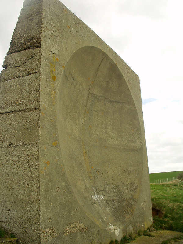
The idea of these is that a microphone could be placed in the centre of the circle cut into the concrete and the sound waves reflecting in the concave circle in the concrete would pick up sound earlier than it could otherwise be heard. Sort of a focusing the sound into the centre of the mirror. The idea was to provide an early warning of aircraft heading over the channel from France where the sound of their engines could be picked up before they could be seen. It was a good idea but quickly superseded by radar and it’s effectiveness had already become very limited due to the increasing speed of aircraft. This is one of only a small number that remain.
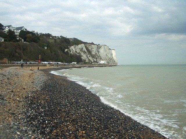
Below me now the undercliff had ended and I could now see the shingle beach far below me. I continued to pass remains of buildings from Word War II this one was presumably used by a gun.

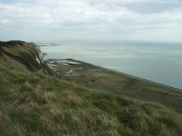
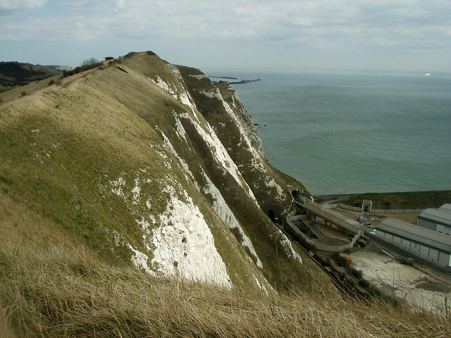
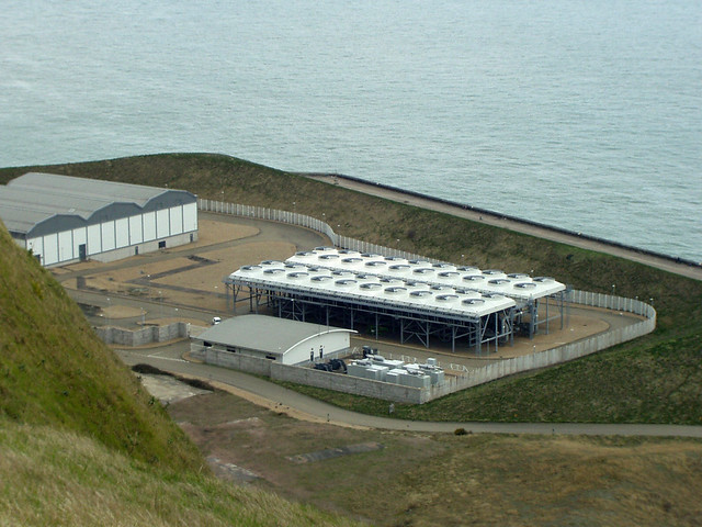
Ahead and at the base of the cliffs was something else of interest. This is the newest bit of England, Samphire Hoe Country Park.

During the construction of the Channel Tunnel a lot of material was excavated to cut the tunnel and this caused a problem of what to do with it all. The solution? Dump it at the bottom of the cliff. The result – Samphire Hoe Country Park! For the name Country Park I have to say it did not look that attractive. A flat area of land mostly covered in grass with hardly any vegetation and a concrete sea wall.
It’s not really what I’d call “country”. Still I expect the new material also provided welcome defence to the cliffs and the railway line that had now emerged from it’s tunnel and was now right along the base of the cliffs again.
I passed another World War II lookout on the cliffs. It must have been busy up here during the war with people scouring the seas for invading forces and aircraft travelling over from France.
Ahead I could make out the large concrete arms of the harbour at Dover, so I was getting close now. A little after Dover I would turn left, having completed the whole south coast and turn to the north. It will be John O’Groats before I reach the end of the east coast!
Below me, in Samphire Hoe, was some industrial looking buildings, perhaps providing ventilation for the Channel Tunnel?
The view in both directions now were good. To my right the white cliffs and English channel and to my left the North Downs. I was walking on a ridge, with the land falling away on both sides now.

Soon the ground fell away ahead too, giving me a view of the ferries in the harbour at Dover ahead and the A20 heading into the port. I could also see some odd structures on the path ahead which I think are ventilation shafts for the railway below.

I soon passed one of the North Downs marker posts, showing 2 miles to Dover (and 122 miles to Farnham!).
Looking back I could still make out Folkestone now looking quite distant. Out to sea I squinted to see if I could see the coast of France too, but I couldn’t. It can be seen on a clear day.
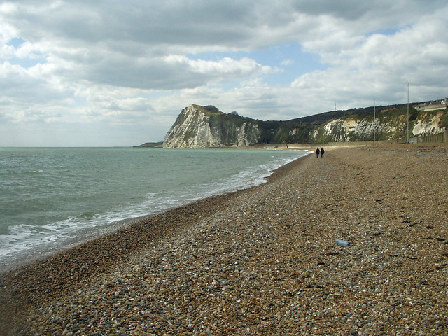
Below me now was a shingle beach stretching all the way to the edge of the harbour at Dover. I could see people on the beach too so there must be a way down and a bridge over the railway line suggested that was the way.

So I decided that rather than continue on the cliff top I’d head down this path to the beach. I was nice to appreciate the cliffs from below where you could see their famous whiteness under close quarters.

I was soon descending and crossing the railway line which had emerged from the tunnel again. The beach turned out to be shingle (it was hard to tell from the top). However I made my way along the beach although it was hard going.

The North Downs Way (and now the England Coast Path, too) heads inland here through an area called Western Heights so this was another reason I wanted to take to the beach. I was hopeful I would be able to get off the beach at the far end though, rather than find it a dead-end.
Thankfully the beach ended at a car park and a road. This was the Dover Western Docks and Admiralty Pier. This used to be the railway station where trains would travel from London and stop right next to boats, for the onward transport to France and beyond. It was looking pretty run-down now as I don’t think it was used by ferries by this point and the railway tracks had long gone, though I think it may be used by cruise ships now.

I now followed the road out of the harbour area. It was not welcoming, with everything to either side behind high metal fences. I passed a pub, the Cinque Port Arms that seemed to be about the only building still standing!
From here I had to follow the main road back to the roundabout on the A20 which I then had to follow for a short while (thankfully, there is a pavement). I was passing a large marina on the right which surprised me, I always though Dover was a ferry port and didn’t have room for leisure traffic as well.

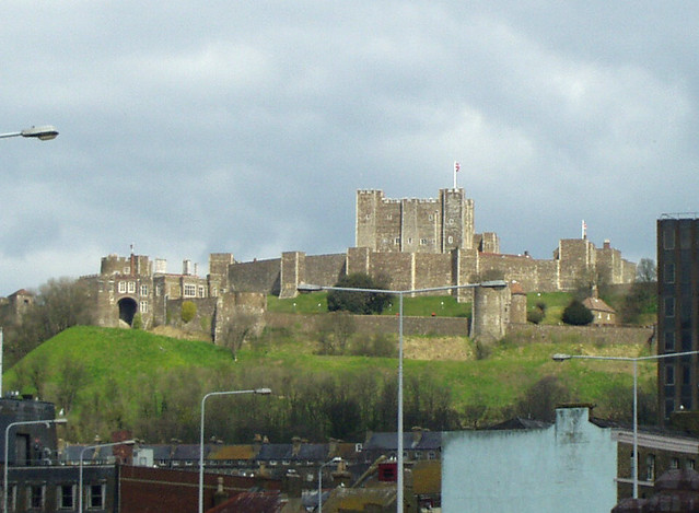
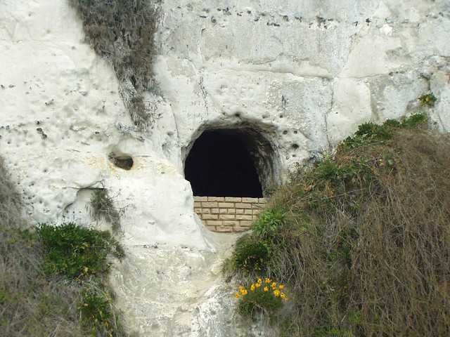
Up on the hill I could see the massive and imposing Dover Castle. It is well worth a visit, I had visited a few years previously and really enjoyed it. I particularly remember the number of tunnels that had been cut into the cliffs under the castle to provide look out in the cliff face!
At a roundabout ahead I head reached the end of the Western Docks and could follow a road over the entrance to the marina and over a bridge back to the shore. This area had been smartened up with new nautically themed shops to go along with the marina. The buildings I suspect were once in military use but were now flats.

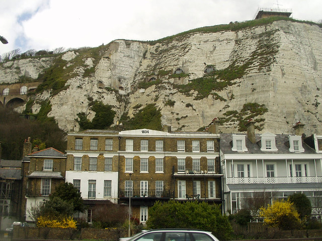
I was pleasantly surprised by this section. I had though the coast in Dover to be largely the industrial port, but here was a nice shingle beach with a promenade behind it and beautiful buildings which I suspect were once all hotels, and many still were.

I hadn’t expected this at all and it was a pleasant surprise. This area too is something of an Undercliff again as I could look above the houses to the high chalk cliffs. You can also see all the tunnels that had been cut into the cliffs from the castle to form lookouts.
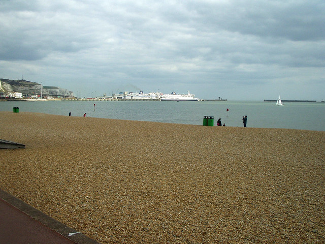
Sadly this didn’t last as I was now approaching Dover Eastern Docks. This is now the main port for cross-channel ferries and I think the only one with passenger services still along the Kent coast. Previously both Ramsgate and Folkestone also had large ferries operating across the channel but now only Dover has the ferries.

The Channel Tunnel and airline have taken a lot of the business. Out in the harbour I could see large ferries of P&O, Sea France and Norfolk Line (only the former of which is still a name you see today, Sea France having gone bust and Norfolk line taken over by DFDS).
Although I had reached the end of the North Downs Way, I had now reached the route of an old friend, the Saxon Shore Way again, which meant I had a well signed route along the coast ahead. This took me up the hill along a track above the harbour and below the castle. Below I could now see the whole of the harbour, and hear the announcements, in a mixture of English and French.

Ferries come and go regularly. Despite the competition from the Channel Tunnel this is still by far the most frequent passenger ferry service to France, with around 50 passenger services operating each day at present (to Calais and Dunkirk). I passed under the access road and the path began to climb further.

Soon I was away from the urban-ness and back in countryside, though the vast port was still below me. Looking back I had a gorgeous view of Dover Castle, too. It is an imposing castle and still largely complete.

Having reached the far end of the port I was now overlooking the Eastern Arm of the harbour. Here the catamaran of Speed Ferries was now departing, to Boulogne.

In fact thinking back this was the last time I used a ferry from Dover. These days I mostly use the Channel Tunnel with Eurostar (which I think is an excellent service), or Eurotunnel if needing a car (as it takes just 35 minutes). The ferries on the other hand take 90 minutes and are less frequent, but you do at least get a view. For many years there was a fast ferry from Dover too which took much less time.
The last time I took a ferry from Dover I opted for Speed Ferries who were operating such a boat at the time and I used them to travel over. On the way out we were impressed with the service and Boulogne is much nicer than Calais. On the way back though, it was a different story. On arrival at the port, after showing our booking we were rudely told “you have to pay a fuel supplement” (I think it was €5 or so). I explained we had already paid for a ticket to which the response was “Yes and this is a supplement to it. You don’t pay, you don’t go, it’s in the terms and conditions”. Well it probably was, but there was no mention of such a charge when booking or on the tickets and nor had we been charged any supplement on the way out, so they certainly kept it quiet in the small print. If we didn’t pay it we would have to drive to Calais and pay for a new ticket. So I reluctantly paid it but vowed never to use Speed Ferries again, I won’t use companies that think this sort of thing is acceptable. I guess I was not the only one, since they went bust a few years later. You think you’ve paid for everything required and then find these extra charges hidden away in the small print. You’d think if you’d paid for a ticket it would surely include the cost of the fuel. I mean how were they expecting to be able to cross the channel without any fuel? Otherwise what exactly have you paid for with your ticket? What next, a “boat supplement”, “captain supplement” or “insurance surcharge”?! They had the cheek to put the slogan “Fight the Pirates” on their boat, but after this trick I thought with this trick that they were the pirates. Anyway enough about ferries.
Now I had passed the end of the ferry port, things were quieter. I had a lovely wide path over the top of the beautiful white cliffs of Dover. They are white of course due to the erosion so it is best not to walk too close to the edge!

I was now rounding the back of an area called Langdon Hole though there seemed to be a lower and more coastal path below. Still I got a better view from up here!

Soon I had rejoined the lower path right along the cliff top again. Weirdly, I could see wires hanging down the cliff face. I’m not sure if they were due to erosion exposing cables in the cliffs or if people were abseiling down them, I didn’t want to look over the edge to see!
This was now a spectacular stretch of coast, with the beautiful chalk cliffs below me and ahead.


In places, small chalk stacks had formed, too. I soon headed into a little valley, Fan Point and this time took the more coastal path.
Ahead was another beautiful feature of the coast, the South Foreland lighthouse, which warns ships against the cliffs in this busy shipping channel. I love lighthouses and this was another beautifully kept one. Although it looked to be in the usual colours of Trinity House, this one was decommissioned in 1988 and is now owned by the National Trust. It’s open to the public though I didn’t go in.

Just beyond the lighthouse I could now see St Margaret’s at Cliffe ahead, my destination for the walk, though it looked bigger than I had expected.
The path was now descending gradually into the village and soon I had to turn a bit inland along the road, passing the windmill and tea room. It was a pretty village which I immediately liked.

Soon I reached the top of the road above the cliffs and road. Here the road zig-zagged down a steep hill to the beach. I couldn’t miss out the opportunity, so I followed the steps alongside it down to the beach. I was extremely glad I did, it is beautiful. It is a shingle bay with white cliffs at either end and also backed by the white cliffs.

Facing east, it is very sheltered in most weathers and indeed it felt much warmer down here. It is very peaceful and seems a world away from busy Dover a couple of miles down the coast.
At the bottom is a pub and a car park and a little promenade. I followed it to the far end where there were a couple of nice looking houses. This was once (probably still is) quite an exclusive place with many celebrities living here. One of the houses was owned by Noel Coward who sold it to James Bond author Ian Fleming. He lived here for 6 years and the area was used as the setting for the Bond novel Moonraker.


I can see why they liked it so much. It is a wonderful spot and exceptionally beautiful. It was not always so though. During the War, many of the houses requisitioned and guns installed on the beach. I could see the holes in the cliffs where I presumed these had once been. Or perhaps they were shelters, I wasn’t sure, other than it was obviously World War II related.

I stopped for a rest and an ice cream here. It was a spot to enjoy before heading home. The sun even began to come out so I got to see the bay at it’s best. It was eventually time to drag myself away and head up the steep hill back to the coast road at the top, where I was rewarded with a good view back to the beach.

I liked the old fashioned signs “Steps to the Beach” and “Slow very dangerous bends”. It felt like the sort of place that had not changed much since the war!

Out of breath at the top of Bay Hill I continued up the green where I was pleased to find the bus stop, which was located at the junction with Lighthouse Road. So called because it doesn’t go to the Lighthouse, if the signs are to be believed! Odd.

The bus arrived on time and gave me a great view of Dover Castle on the way back. I was soon back at Capel-le-Ferne but before leaving I stopped to take a few more photos of the beautiful white cliffs below me, now in the early evening sun. It makes me rather proud that this beautiful stretch of coast is still the first sight of the UK many people have when arriving from France.
I really enjoyed this walk. It was beautiful throughout, over the famous white cliffs. Even the only sizeable town, Dover, turned out to be much nicer than I had expected. The views were excellent the paths easy and the beach at St Margaret’s at Cliffe proved to be a fitting end and an unexpected treat. I was glad I had ended here, as it meant I would be coming back again for my next walk!
Here are details of the public transport needed for this walk. It is necessary to change busses in Dover:-
Stagecoach buses route 15 : Sandown – Deal – Walmer – St Margaret’s Bay – Dover – Lydden – Canterbury. Hourly Monday – Saturday and once every two hours on Sunday. It takes around 25 minutes between St Margaret’s Bay and Dover.
Stagecoach “The Wave” routes 101, 102 and 103 : Dover – Capel-le-Ferne – Folkestone – Sandgate – Seabrook – Hythe – Dymchurch – St Mary’s Bay – New Romney – Greatstone – Lydd-on-Sea – Lydd. Some buses continue past Lydd to Hastings via Rye. The bus runs 4 times per hour Monday – Saturday and twice an hour on Sundays. It takes just over 10 minutes between Dover and Capel-le-Ferne.
Here are the complete set of photos for this walk : Main Link | Slideshow

This is a beautiful part of the coast, and one you can’t really appreciate when you arrive by car and roll onto the ferries. Love the concrete ears and the WW2 defences, and glad they’re still there and not tidied up.
Thank you – your blogs are really informative. I am planning to do this section next month.
Thank you for your kind comments! I hope you enjoy the walk.